Photo: A Climber’s Guide to Glacier Peak Mountain In Washington
I’ve done some minor exploration and adventuring in my life. Some of my adventures caused significant or life-changing events.
Some of my life events scare, thrill, or inspire me. This one did all three! It made me look at the world and myself in truly different ways.
Here’s what happened.
I got lost for a day in a “white-out” while hiking across a glacier in snowy mountains with 7 other “city kids” with no adults around! Oh my!
- We were scared — we had to find our own way out.
- It was thrilling — especially when we did find our way out.
- It inspired me — how to work as a team and how to stay cool.
At 16 years old I went to the Northwest Outward Bound School near Seattle, Washington, USA for 21 days in June-July 1977. There, I mountaineered with other teenagers, mostly from cities and suburbs like me, in the North Cascade mountains.
The 21-day course entailed 17 days of hiking and instruction with the final four days called the “Final Expedition”.
Aside: I went to NWOBS because I was a member of Land Rescue Team 10 (LRT-10) in Civil Air Patrol (CAP), Wisconsin Wing. LRT-10 was at Timmerman Airfield in northwest Milwaukee. Now, in 2023, the CAP unit at Timmerman Airfield is the Timmerman Composite Squadron.
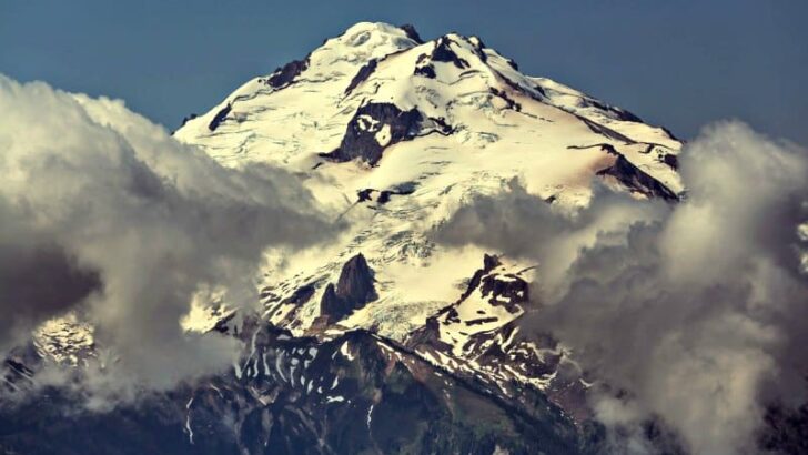
Glacier Peak summit then down into a glacier

[Pixabay – abbasali – free photo]
After 16 days of hiking, camping, eating, and training with our two instructors, my Final Expedition “patrol” of eight teenage boys set out to show what we’d learned. For four days, we had to navigate, hike, camp, eat, and sleep on our own. We had to reach a checkpoint every 24 hours… without being too late! The instructors were at each checkpoint waiting for us… unless we beat them there. Yeah, sure, right.
On our Final Expedition, our instructors did step in to help us reach the summit of Glacier Peak at 10,541 feet (3,213 meters) — woohoo!! And then they turned us loose again to hike on our own to the next checkpoint. We were feeling pretty good and confident. We were getting good at this, or so we thought.
We plotted our best course down from Glacier Peak on the map. We would hike right over the flat area of a glacier to our next checkpoint located a few miles south of Red Pass on the Pacific Crest Trail. The glacier was Scimitar Glacier just WNW of Glacier Peak.
Atop Glacier Peak, we looked down and saw clouds below us. We could not see how deep the clouds went. Well, we just shrugged a bit and hiked on straight “into the mist” of the glacier.
During the Final Expedition, our two instructors shadowed us while staying out of sight so we could navigate on our own. As we set off, we looked back and saw them take a different route. They did not follow us into the glacier. We wondered why but we knew what we were doing. Of course!
Ha! Were we in for a scary experience!
We are lost!

[Caltopo map site]
Trudging through ankle- to knee-deep snow, unable to see any landmarks, roped together and probing for crevasses with our ice axes, we quickly veered off our expected course while on the glacier. We used dead-reckoning navigation with just a compass heading. Bad idea! We were right in the middle of a cloud, I mean a white-out on a glacier! No wonder we got off course.
Remember this was in 1977. The first prototype GPS satellite did not launch until 1978. All we had was a map, a compass, 2 weeks of training, and lots of willpower and naiveté. We were fine!
After wandering several hours in the mist going in some sort of direction, we stopped on a hillside. We were soaking wet, exhausted, frustrated, and getting a little scared. We really didn’t know where we were. The few rock outcroppings and noise from rivers and waterfalls were just too ambiguous to pinpoint our location on the topographical map.
We needed to rest and think straight. We pitched our tarp, crawled underneath, and heated and drank hot water with powdered jello to restore some energy. It was about 2 in the afternoon. We needed to reach our checkpoint by midnight. Twelve hours after that, the instructors would personally hike around to find us. Twenty-four hours after our deadline, the sheriff’s helicopters would be called in for search and rescue. That would be really embarrassing, right? Not happening! So we had to figure this out.
Find out where we are

[Footprints in the snow – free photo by walkman200]
We needed more information about our surroundings.
There were eight of us in our patrol. We split up into three pairs to go on reconnaissance runs while two people stayed at our makeshift tarp camp. There was still snow on the ground despite it being early July. Wonderful! We could easily see our own tracks if a pair did not return. Each pair went off in three different directions to find some landmark, stream, or trail marker. I stayed at camp “coordinating” the efforts (I was such a planner-type) and kept the jello water hot; someone had to, right?
After 30 minutes, each pair successfully returned, thank goodness. No one found anything useful though. Now we’re getting especially worried.
We had two choices. Sit and wait for someone to find us or hike our way out.
What did we do? You guessed it! We hiked our way out. We couldn’t just sit there all night with about 3 hours of daylight left. So we packed up our gear and simply hiked in a general direction towards our checkpoint, wherever that was.
Ten minutes after we descended from our little “tarp-and-hot-jello hill,” we walked across two sets of fresh footprints in the snow. “Are those your footprints?” we asked each of our reconnaissance pairs. “No, no, no!” they replied. None of us made those footprints! Someone else was nearby, out in the middle of nowhere … you gotta be kidding me … way out in the North Cascades!
“Follow those tracks wherever they go,” we decided. After about 30 minutes we encountered a man and woman sitting at their small tent camp drinking hot something–jello perhaps?–in the snowy treeline. We were so happy!
“Where are we?” we asked holding out our map. “We aren’t quite sure,” one of the hikers replied.
Oh no!
“But we started over here on the map, we think we are here, and we are headed to Red Pass,” the hiker continued.
We looked at each other and something clicked! It all made sense now: what we heard, what we saw, and the hills and the turns in the thick of the white-out. We had drifted off our course; we now sort of knew how and where.
Hoorah! We thanked them, offered them a couple of trail biscuits, waved, and hiked on.
With only a couple more hours of daylight, we hiked up the valley as far as we could until it was too dark to see. We dug shallow trenches in the snow to sleep in and tied our tarps to our metal-framed backpacks and ice axes. We crawled into cozy, wet sleeping bags wearing drenched clothing. It was not cold out, just wet. We slept peacefully for several hours and got up at the first light.
The final stretch

[Pixabay – riyan_hidayart free photo]
It was a new day and we were now about six hours overdue from our midnight checkpoint. We wasted little time packing and eating as we quickly got underway up the valley towards Red Pass. We had high hopes, but were were fast approaching our high-noon 12-hour overdue time. We were getting anxious again.
Hiking and hiking and hiking, then … a trail … and then a marker! Pacific Crest Trail! Hooray! We found it! We weren’t lost anymore!
We hiked south on the trail for a couple of miles. Turning a corner, we saw our two instructors sitting on a log at their camp having some sardines for lunch. It was about 12:30 PM (12-1/2 hours late). Without getting up from their delicious meal, they casually looked at us and simply said “Hello there.”
We tried not to look too anxious, embarrassed, or scared. We said, “Hi there. Um, we’re a little late. We got a little lost.”
Will, our main instructor replied, “Yes, we know. You were down in the valley northeast of Red Pass, right? It’s the first place we’d go looking.”
We were astonished they figured that out! “How did you know?” we asked.
Daniele, our other instructor, said, “We know this area pretty well. When we saw you go down onto that glacier, we could see where you’d drift on your course. We knew where to look.”
“Are we the first patrol to get lost on you?” we asked.
“Not at all,” Will chuckled which relaxed us a bit. “You see that forest below us in the valley? A patrol got lost down there a few years ago for two days. They decided to sit down and stay put, not try to hike out. When they heard the sheriff’s helicopters, they came out. We’re glad you kept hiking and found your own way here. We knew you would. I hate hiking out to call the sheriff. Congratulations!”
We were relieved. Being pretty exhausted, all we could say was, “Mind if we sit down for a bit?” We all laughed and opened some cans of sardines and heated some jello.

[gaiagps.com – Red Pass via Pacific Crest Trail]
Become Inspired!


We all have adventures and challenges in our lives leading to different checkpoints. We don’t necessarily need an Outward Bound course to learn how to get to those checkpoints (but it helped me in the long run–many times).
You have an objective, a checkpoint. You plan, proceed, try, learn, adjust, get anxious, adjust more, and finally succeed. You might also Observe, Orient, Decide, and Act (the infamous OODA Loop). You may also get a little help or nudge along your way too.
Don’t “sit down and stay put” when you get lost.
Pause when needed to look around.
When things don’t go right, it can be easy to just stop. Take a break, let your mind clear, and even let your subconscious analyze your problem while you relax. Then get up and get going again.
Give a little something to those who help you.
You may find help along the way. It may be some advice, some observation, or just simply talking about your situation. Give them something back after that because they showed they cared. You could give them a hug, handshake, or something out of your backpack like some trail biscuits.

.svg)